« Christmas 2013 | Main | Photo Stream/iCloud Control Panel 3.1 with Windows XP »
January 10, 2014
Map of Mississippi Circa 1822
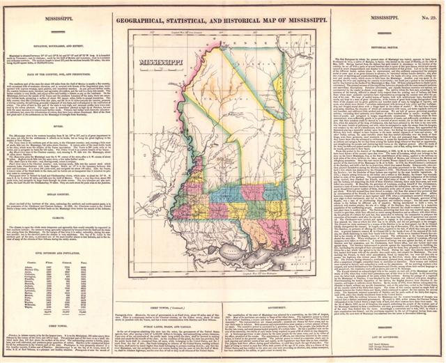
Here's the text of the map as an MS Word document.
Here's the text of the map as a PDF document, viewable in any PDF viewer, such as Adobe's Acrobat Reader (free).
Note that, in both of these documents, I have attempted to reproduce the text of the original image as accurately as practicable, down to and including spelling mistakes, formatting, indenting, italics, etc.
To view the full-sized high-resolution version of the map, click on the map above, or click here to see the Full-Sized Image below (in extended entry).
View more Historical Maps of Mississippi.
Full-Sized Image below (in extended entry).
MISSISSIPPI.
────────
¯¯¯¯¯¯¯¯¯¯¯
SITUATl0N, BOUNDARIES, AND EXTENT.
Mississippi is situated between 30° 10' and 35° N. lat. and 11° 10' and 14° 25' W. long. It is bounded north by Tennessee; east by Alabama; south by the Gulf of Mexico and Louisiana; west by Louisiana and Arkansas Territory. The medium length is about 275 and the medium breadth 165 miles; the area being 45,350 square miles, or 29,024,000 acres.
FACE OF THE COUNTRY, SOIL AND PRODUCTIONS.
The southern part of the state for about 100 miles from the Gulf of Mexico is mostly a flat country, with occasional hills of moderate elevation, and is covered with forests of the long-leaved pine, interspersed with cypress swamps, open prairies, and inundated marshes. As you proceed farther north, the country becomes more elevated, and agreeably diversified, and the soil is a deep rich mould. The Indian country is very fertile, and enjoys as fine and healthy a climate as any on the continent. On the Mississippi, between the mouth of the Yazoo and the Southern boundary the state, there are extensive bottom lands, occupying a surface of about 600 square miles, liable to annual inundation. The hilly country rises like a buttress from this plain, and for 10 or 15 miles towards the interior, presents a waving country, the soil being generally composed of rich loam, and well adapted to the cultivation of cotton. The price of land in part of the state is very high, and immense profits have been realized by the cotton planters. The sugar cane is sometimes planted as high up as Natchez, but not with the same success as is experienced farther south. Tobacco and indigo were formerly extensively cultivated, but, since the introduction of cotton, they have been almost abandoned. Most of the flour and grain used in the settlements on the Mississippi is brought from Kentucky.
RIVERS.
The Mississippi river is the western boundary from N. lat.35° to 31°, and is of great importance to the state, not only for the settlements it affords on it: banks, but as being the great highway to the market at New Orleans.
The Yazoo rises in the northern part of the state, in the Chicasaw country; and, running a. little west of south, falls into the Mississippi, 140 miles above Natchez. It waters some of the most fertile lands in the state, which were the subject of the Yazoo speculation. The Yazoo is 200 yards wide at its outlet, and is navigable by boats for 150 miles. The Yellow Creek is an eastern branch of the Yazoo.
Big Black River rises in the Choctaw country; and, running S. W. falls into the Mississippi, about 50 miles above Natchez.
The Homochitto joins the Mississippi near the S. W. corner of the state, after a S. W. course of about 70 miles. Buffaloe creek falls into the same river, a few miles farther south.
The Amite rises in this state; and, flowing south, enters Louisiana.
Pearl river rises in the Choctaw country; and, running south, falls into the narrow strait which connects Lake Pontchartrain with Lake Borgne. Below lat 31° it is the boundary between this state and Louisiana. It is about 200 yards wide, and navigable for about 150 miles. Like the Yazoo, it waters some of the finest lands in the state, and its waters are so transparent that it received its present name in consequence.
Pascagoula river is formed by Leaf and Chickasawhay rivers, which unite in about lat. 31° N. It runs S. E. by S. about 40 miles, and falls into the Gulf of Mexico. This is a very fine river, about 200 yards wide, and navigable by large boats through its whole course. The two branches are also navigable, the Leaf 30, and the Chickasawhay 70 miles. They are each about 80 yards wide at the Junction.
INDIAN COUNTRY.
About one-half of the territory of this sate, embracing the northern and north-eastern parts, is in the possession of the Chickasaw and Choctaw Indians. In 1820, the Choctaws ceded to the United States a large tract, including all their lands on the Mississippi river below the mouth of the Arkansas.
CLIMATE.
The climate is upon the whole more temperate and agreeable than would naturally be expected in that southern latitude; the summers being agreeably tempered by breezes from the Gulf and the moisture arising from the Mississippi. On the margin of that river it is rather unhealthy, during the summer months; but in the elevated parts the climate is very salubrious. The bay of St. Louis in the southern part of the state, is esteemed one of the most healthy places in that latitude, and in the retreat of many of the citizens of New Orleans during the sickly season.
CIVIL DIVISIONS AND POPULATION.
Counties. Whites. Colored. Total.
Adams, 2557 7335 9892
Natchez City, 1448 736 2184
Amite, 4006 2847 6853
Claiborne, 2840 3123 5963
Covington, 1824 406 2230
Franklin, 2277 1544 3821
Greene, 1063 382 1445
Hancock, 1142 452 1594
Jackson, 1300 382 1682
Jefferson, 3154 3668 6822
Lawrence, 3919 997 4916
Marion, 1884 1232 3116
Monroe, 2192 529 2721
Perry, 1539 498 2037
Pike, 3443 995 4438
Warren, 1401 1292 2693
Wilkinson, 3937 5781 9718
Wayne, 2250 1073 3323
______ ______ ______
42,176 33,272 75,448
______ ______ ______
CHIEF TOWNS.
Natchez, in Adams county, is by far the largest town. It is on the Mississippi, 320 miles above New Orleans by the course of the river and 156 by land. The principal part of the town is on a bluff, elevated more than I50 feet above the surface of the river. The surrounding country is fertile, populous, and well cultivated, and produces great quantities of cotton. Natchez is the commercial depot for all the settlements in the western part of the state. Washington is very pleasantly situated in a fine healthy country, 6 miles east of Natchez. Shieldsborough is on the bay of St. Louis, about 40 miles N.E. of New Orleans, in a pleasant and healthy situation. Pascagoula is near the mouth of
CHIEF TOWNS. ( Continued.)
Pascagoula river. Monticello, the seat of government, is on Pearl river, about 90 miles east of Natchez. Elliot is a missionary station in the Choctaw country, on the Yellow creek, about 30 miles above its junction with the Yazoo, and has a water communication with Natchez and New Orleans.
PUBLIC LANDS, ROADS, AND CANALS.
In the act of congress admitting this state into the union, the government of the United States agreed, that, after paying a debt of 1,250,000 dollars to Georgia, and indemnifying certain claimants, 5 per cent. of the net proceeds of the public lands lying within the state, shall be devoted to making roads and canals for the benefit of the state. As the condition of this grant, the state has provided, that the public lands shall be exempted from all taxes, while beloning to the United States, and for 5 years from the day of sale; that lands belonging to citizens of the United States, residing without the state, shall never be taxed higher than lands belonging to persons residing therein; and that the river Mississippi, and the navigable rivers and waters leading into the same or into the Gulf of Mexico, shall be common highways, and for ever free of toll or duty to all citizens of the United States.
GOVERNMENT.
The constitution of the state of Mississippi was adopted by a convention on the 15th of August, 1817. Most of its provisions are similar to those of the other states. The legislative power is vested in two distinct branches, a senate and house of representatives, which form together "The General Assembly." The representatives are chosen annually; senators are chosen for three years, and vacate their seats in rotation. Both senators and representatives must possess a certain amount of landed estate. The executive power is exercised by a governor, chosen by the people, who holds his office for two years, and must possess landed property of a certain value. He has a qualified veto on the acts of the assembly, two-thirds of each house being required to pass a bill of which he has disapproved. A lieutenant-governor is also chosen by the same people for the same term, and is, by virtue of his office, president of the senate. The appointment of officers, not otherwise directed by the constitution, is vested in the general assembly. The Judicial power is vested in a supreme court, and m such superior and inferior courts of law and equity, as the legislature may from time to time establish. The hold their offices during good behaviour, or until they reach the age of sixty-five. The right of voting is vested in each free white male person of the age of 21 years, who is a citizen of the United States, and has resided in the state one year next preceding an election, and, unless exempted, has been enrolled in the militia, or paid a state or county tax.
MISSISSIPPI. No. 29
────────
¯¯¯¯¯¯¯¯¯¯¯
HISTORICAL SKETCH.
The first European by whom the present state of Mississippi was visited, appears to have been Ferdinand de Soto, a native of Badajoz, in Spain; who landed on the coast of Florida, on the 25th of May, 1539. Having learned from the Indians that gold existed in abundance in the interior of the country, he set off with a party of several hundred men in quest of this ignis fatuus, which had already caused so much disappointment and disaster to the adventurers of that period. Led on by the reports of the different Indian nations whom he encountered, and who uniformly represented the precious metal at some spot at no great distance in advance, he traversed various remote districts; and, after two years of marching and countermarching, arrived on the banks of a deep river, with a strong current and muddy water, which seems to have been the Mississippi. Another year was spent in descending the river and exploring the country in its vicinity; but death put a period to his enterprises, and he was buried on the banks of the Mississippi, in May, 1542. Of these principal facts no doubt can be entertained. The printed account of this expedition, however, abounds with the most romantic incidents and marvellous descriptions. Fabulous adventures, and equally fabulous countries and nations, are encountered by the reader in almost every page. The natives whom De Soto met, according to the historian of his travels, differed in almost every respect from the existing race of Indians, and from those whom more authentic narratives have represented as occupying the country soon after the period of his visit. We hear of walled towns, of houses built with architectural taste, thatched with reeds, and kept in a state of great cleanliness; of the houses of great lords being distinguished from those of the meaner sort by great galleries and benches made cane, by hangings of tapestry, and seats, over which were thrown "coverlets embroidered with devices of very wittie and fine workmanship, and fringed round about with a fringe dyed in the colour of scarlet." We find these Indians possessing churches, the steeples of which are surmounted with vanes, and fields regularly surveyed and bounded, and cultivated with method and success. We are told of queens governing populous nations; extending their authority over districts of three hundred miles in extent; wearing neck-laces of pearls; and navigated in barges magnificently ornamented. The Indians whom De Soto encountered, were sufficiently gentle to be great admirers of music, and sufficiently credulous to suppose that their invaders could be moved by a concord of sweet sounds; for we find that on one occasion, when the subjects of the king of Caliqueen, who had been arrested by De Soto in his own territory for some breach of politeness, and who, when he attempted to make his escape from his keepers, was retaken by the aid of a bloodhound, were desirous of obtaining his release, they approach the Spaniards playing a mournful melody upon their flutes; but finding this species of remonstrance ineffectual, they were obliged to have recourse to the more natural argument of bows and arrows. Of other Indian nations, the same traveller states that they carried umbrellas over the heads of their kings, wore linen garments, used standards in time of 'war, and possessed dogs. Notwithstanding they found them thus far advanced in civilization, it seems the Spaniards still considered them in fact as outlaws and savages, for we find them seizing the Indian kings whenever they had an opportunity, and slaughtering the people and destroying their towns on the slightest pretext. After the death of De Soto, his followers passed another year in this country; and at last, sailing down the Mississippi to its mouth, proceeded to New Spain.
From this period to the descent of the Mississippi, in 1683, by M. de la Salle, little more seems to have been known of the country upon that river. The name of Louisiana, which now belongs to the state on the lower Mississippi, was, at the first establishment of the colony, applied to the territory on both sides of the river, between the lakes and the Gulph of Mexico, and between the Mexican and Alleghany mountains. Over this vast extent of country France claimed to have jurisdiction, in consequence the discovery of the Mississippi by M. de la Salle. In 1716, the French formed a settlement at the Natchez, and built a fort for its protection, which they named Rosalie. Subsequently, other settlers planted themselves among the Natchez Indians, and some penetrated to the Yazoos, where they built a fort, which was destroyed by the Chicasaws in 1722. The French were favourably received by the Natchez; but the kindness of these Indians was requited by the most horrible ingratitude. In 1723, a dispute arising between an old Indian and a soldier at fort Rosalie, the former was wantonly killed by some of the garrison. The perpetrators went unpunished, and the indignation of the Indians being excited, they attacked the French, and killed many of them. At last peace was restored, and the Indians, not suspecting the faith of those Christian colonists, threw aside their arms, and were lulled into security. M. Beauville, the governor of Louisiana, availing himself of this circumstance, marched a body of seven hundred men to the fort, attacked the defenceless natives, and having inhumanly slaughtered a great number of them, demanded, as the price of peace, the head of their principal chiefs. With this demand they were forced to comply ; but from that moment they perceived that an extermination of the French, or their own abandonment of the country must take place. Affairs, however, remained without an open rupture until 1729, when a circumstance occurred which gave a new edge to their resentment, and led to the final catastrophe. M. de Chopart, governor of fort Rosalie, was a man of an overbearing disposition and vindictive temper; who had made himself odious to the Indians by different acts of injustice. Having determined to build a town, he selected, with wanton cruelty, the site of a village of the Natchez, then occupied by a numerous population of the unoffending people. Accordingly he directed the chiefs to remove the inhabitants, and plant them in another place. The Natchez, perceiving that their ruin was resolved upon, endeavoured to gain time, while they effected an union among themselves and an alliance with other tribes. By the promise of a tribute for each hut, they succeeded in inducing the commander to postpone the execution of his resolve until after the harvest. In the mean time the plan of operations was concerted. The Chickasaws were invited, and agreed to engage in the enterprise. By some misfortune they mistook the time at which the blow was to be struck, and did not participate in the struggle. The French too were cautioned by a woman of the Natchez to be on their guard; but M. de Chopart blindly disregarded the counsel. At length, on the last day of November, 1729, the flame burst forth. The Natchez, on pretence of offering the tribute, repaired to the fort, of which they soon got possession. A general massacre ensued, M. de Chopart fell by the hands of one of the meanest of the Indians, the chiefs disdaining to stain their hands with his blood. Of the seven hundred French then settled in the vicinity of fort Rosalie, very few escaped. The settlements at the Yazoos and Washita
shared the same ate. When intelligence of this disaster reached the capital of Louisiana, effectual measures were taken to retrieve it. A detachment of troops was sent against the fort, of which the Natchez now had possession, and the Chickasaws, their former allies, now also turned their arms against them. The Natchez endeavoured to provide against the impending danger by fortifying the fort; but finding the strength of their adversaries too great for them, they proposed a cessation of hostilities for a day, which was agreed to by the French. During the night they silently deserted the fort, loaded their boats with the plunder they could carry, and crossed the Mississippi. The next morning the French, to their utter astonishment, found an empty fort; but were not then able to pursue the fugitives, who retired about 180 miles up Red river, where they erected a fortification. The French, having obtained a reinforcement, pursued them, attacked them in their fort, and, after a sanguinary struggle, compelled them to surrender at discretion. Their women and children were reduced to slavery, and compelled to work on the plantations. Of the surviving warriors a few escaped, and united themselves to the Chickasaws and Creeks, among whom their ancient language is still preserved; the remainder were sold as slaves, and sent to St. Domingo.
The French retained an acknowledged title to the country on each side of the Mississippi until the treaty of 1763, when they ceded their possessions east of that river to the English. In the succeeding year, the latter took possession of the posts within this territory. During the passage of a regiment up the Mississippi to Natchez, it was attacked by the Tonnicas, and defeated with great slaughter. Notwithstanding the hostile disposition of the natives, the English directed their attention to the country, and began to cultivate about Natchez. By the treaty 1783, Great Britain relinquished the Floridas to Spain, without any specific boundaries; and, at the same time, ceded to the United States all the country north of the thirty-first degree. The terms of this cession opened an ample field of dispute between the United States and Spain, which continued to agitate the two nations for several years. The Spaniards retained possession of Natchez and the posts north of the thirty-first degree, until 1798, when they finally abandoned them to the United States.
In the year 1800, the territory between the Mississippi and the western boundary of Georgia was erected into a distinct territorial government. By treaty in 1801, at fort Adams, the Choctaw Indians relinquished to the United States a large body of land, and other cessions have since been made. On the 1st of March, 1817, an act of Congress was passed, authorising the people of the western part of the Mississippi territory to form a constitution and state government, and providing for the admission of the state thus formed into the union. Accordingly a convention met in July, 1817, by which a state constitution was formed : and the provisions required by the act of Congress having been complied with, the new state of Mississippi was admitted into the union on December following.
────────
¯¯¯¯¯¯¯¯¯¯¯
LIST OF GOVERNORS.
1817 David Holmes.
1819 George Poindexter.
1821 Walter Leake.
Posted by Rob Kiser on January 10, 2014 at 7:45 PM
Comments