« April 2019 | Main | June 2019 »
May 31, 2019
Friday's Ride
So, today I started out by riding up Trail Creek Road (Clear Creek County Road 136) outside of Idaho Springs. Took Trail Creek Road up past the Phoenix Mine, and then turned left onto South Spring Gulch Road (County Road 130) and follow County Road 22 uphill until it's snowed in and I can't go any further.
At this point, I turned around and headed back downhill, and followed South Spring Gulch Road (County Road 130) straight downhill all the way out to Colorado State Highway 103 (the road to Mount Evans). I should point out that this hill is very steep, and would be difficult to climb. I had a hard enough time just going down it.
Then, into Idaho Springs for lunch at Carl's Jr.
After that, I rode up Hidden Wilderness Road. There was much less snow, and I made it further this time than last time, but the road dead ends into someone's private property. There's a gate that basically stop you from going any further.
My Garmin Montana is basically as useless as tit's on a bull, as I'd just upload the GPS tracks to map them out, but the Garmin is not functioning properly at this time. I have ordered a new battery pack for it.
So, in any event, I came back down from the dead end that I ran into, somewhere near the summit of Santa Fe Mountain.
Then, up Fall River Road to York Gulch (County Road 277). Up York Gulch to Bald Mountain Road. Then down to King Flats Road, to Columbine Campground Road, to Forest Service Road 739.1, and back up in a big loop back to York Gulch on Forest Service Road 739.1.
Then, north towards Yankee Hill, until I came to a big washed out/flooded section of the road that I didn't feel like trying to go through. Turned back and headed out York Gulch. On the way back, though, I took another big loop up Old Stage Road, to Alpine Way. I don't believe I'd ever been on this loop before.
Today's Ride: Part 1
Today's Ride: Part 2
Posted by Rob Kiser on May 31, 2019 at 6:40 PM : Comments (0) | Permalink
May 30, 2019
Today's Rides
Today, I started out by riding up to Echo Lake. The road is cleared from my ride up here yesterday in the BMW X3. So, I was able to make it all the way to Echo Lake. However, the gates are closed and locked at Echo Lake, and it is not possible to ride up to Summit Lake at this point.
I saw a couple of guys on Suzuki's. Talked to them for a little bit at Echo Lake Lodge over coffee.
Then, I rode down towards Idaho Springs. I went up Cascade Creek just a short distance, to the shooting range. Then, I went up Ute Creek to the turn off for Lamartine Road. Then, down into Idaho Springs for lunch at Carl's Jr.
After lunch, I tried to ride up to Chinn's Reservoir, but it's still snowed in, of course. Then, I went to Alice and tried to ride up to Loch Lomond, but it's still snowed in also. There are 2 gates to get to Loch Lomond, and they're reportedly opening the first gate on Saturday June 1st.
It snowed on my (very lightly) several times today, first up near Echo Lake, then several times near Alice and St Mary's Glacier. It seems like, once I get about 10,000 feet above MSL, it snows pretty much every day.
Posted by Rob Kiser on May 30, 2019 at 7:23 PM : Comments (0) | Permalink
May 29, 2019
State Struggles to Open Mountain Passes
The Colorado Department of Transportation plans to have the road to Aspen over Independence Pass open at 5:30 p.m. Friday (May 31st). Meanwhile, it hopes to have the Mount Evans Highway partially open by the end of the week. (Saturday June 1st?)
Milner Pass/Trail Ridge Road in Rocky Mountain National Park is not open.
Posted by Rob Kiser on May 29, 2019 at 6:04 PM : Comments (0) | Permalink
Mt Evans/Echo Lake? Not So Fast...
Today, I tried to drive the BMW X3 up to Mt Evans/Echo Lake, and didn't make it. The first section of the road to Echo Lake is named Squaw Pass, and then changes to Colorado State Highway 103 at, or near, Little Bear Creek Road. It's 18 miles from Colorado State Highway 74 to Echo Lake, and then 14 miles from Echo Lake down to Idaho Springs. So, the mile markers count down to 14 as you drive up to Echo Lake (from Colorado State Highway 74). 4 miles before Echo Lake, at approximately Mile Marker 18, (just past Echo Ski Park), at approx. 10,600 ft above MSL, it started snowing so hard that I had to turn back. There was 1"-2" of snow on the road, and the BMW tires are not good. Pretty much bald. So, I did a U-turn (in front of a large dump-truck), and headed back down the mountain. Now, keep in mind that it's very nearly June. Global Warming is killing us this year.
It was dicey driving on the road with bald tires in the snow. But, better than being on the Honda Africa Twin motorcycle, I think. My understanding was that the road was open up to Summit Lake Park, but I couldn't even make it to Echo Lake.
Posted by Rob Kiser on May 29, 2019 at 6:04 PM : Comments (0) | Permalink
Mountain Pass Openings
Trail Ridge Road
Where is it? The connection between Estes Park and Grand Lake, through Rocky Mountain National Park, is the highest continuous road in the United States. In a state chock full of 14ers, it's nice to have a road with maximum elevation of 12,183 feet.
Is it open? Nope. Snow plows are trying to clear it, but a park press release said it just keeps snowing. There's no estimated opening date yet -- though if you're feeling up for it, you can bike or hike portions of the road.
Mount Evans Scenic Byway
Where is it? Echo Lake Park to the Mount Evans Summit, about 60 miles west of Denver.
Is it open? Not all of it. Colorado Department of Transportation spokeswoman Lisa Schwantes said the road will open this weekend to Summit Lake Park, which is about 1,500 feet below the peak.
Independence Pass
Where is it? This is the shortcut to Aspen from the Front Range, through Leadville and over the Continental Divide at 12,095 feet.
Is it open? Nah. Forget about it. Schwantes said plows are dealing with 5- to 12-foot high snow drifts and the constant threat of avalanches. "We've had an extraordinary year for snowpack," she said. There's no time frame yet to open the pass.
It's still pretty snowy up on Independence Pass outside of Aspen, Colo., May 2019.
Courtesy of Colorado Department of Transportation
Cottonwood Pass
Where is it? This road that connects Crested Butte to Buena Vista has been closed since 2017 -- crews have repaved it and laid fiber-optic lines.
Is it open? Um, no. Wet, heavy snow is slowing construction work. Best case scenario, Gunnison County officials say, is a July 1 opening to one-way traffic.
Kebler Pass
Where is it? This dirt road connects Crested Butte to Paonia and the North Fork Valley. It's well-known for its stands of Aspen trees.
Is it open? Nope. Schwantes confirmed snow will keep that road closed too. Local officials can't yet estimate when it'll be open either, the Crested Butte News reports.
Posted by Rob Kiser on May 29, 2019 at 1:49 AM : Comments (0) | Permalink
May 24, 2019
The Prodigal Cat
Today, Jen and I woke up and, for the first time in 3 days, it wasn't snowing or raining or anything stupid like that. Today, we woke up, and laid in bed for a bit.
Jen has been very sick. Earlier this week, she went to the doctor in Boulder, and got a prescription for something...a sinus infection? And she took her medicine, and slowly got better.
Today, as the weather was nice, I convinced her that we should go into the mountains.
"Let's drive up into the mountains. We can go to one of the mines in Idaho Springs or Georgetown. Eat lunch up there. Hit Guanella Pass. Let's just get out and do something. Too nice to lay in bed."
"But I don't feel good. I've been very sick this week." she complained.
"I know, but I'll drive. Let's just get out and do something and you'll feel better," I offered.
Like, I can't tell you what it's like to raise an only child, and then have her go away to college, but it's not good.
"OK. We'll leave in an hour. I should feel better then," she offers.
"Fair enough."
So, in an hour or so, I get a camera cobbled together so I can snap some pics if we run into anything, and we head out.
Now...Prince Tubby has been missing for roughly 10 days, and we both know this, but we don't talk about it. It's too traumatic to discuss. Prince Tubby, son of Wallie, is the largest cat we have, and the only one with long hair. A true royal prince. But he's gone now. Someone else in the neighborhood lost their cat, so I'm thinking either a coyote or a lion got him, but he's gone, and we don't talk about this. Too depressing to consider.
At some point in the afternoon, we climb into Jen's VW Tiguan and head off towards Idaho Springs.
At Idaho Springs, we stop for lunch. Always, I eat at Carl's Jr. Everyone there knows me by name, and welcomes me when I walk through the door. But today, Jennifer says we'll eat at Smokin' Yards BBQ, and so it is.
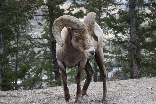
We go there for lunch, and it's delicious, and now we head out and I offer, "Let's go up to Georgetown and hit Guanella Pass. If we get lucky, we'll see some Bighorn Sheep."
"Sure," she says.
-----------------------------
The Mount Evans Road WILL NOT OPEN for the season on Friday May 24, 2019 due weather conditions and snow removal. There is not an estimated opening date at this time.
Road to Maroon Bells opens Friday; Independence Pass gets closer as opening remains on hold.
Trail RIdge Road opening delayed.
Continue reading "The Prodigal Cat"
Posted by Rob Kiser on May 24, 2019 at 9:13 PM : Comments (0) | Permalink
Guanella Pass Open
Jen and I drove across Guanella Pass today (opening day) 5/24/2019 in her car.
Independence Pass - Not open yet.
Trail Ridge Road - Not opened yet. Delayed opening.
Mt Evans - The Mount Evans Road WILL NOT OPEN for the season on Friday May 24, 2019 due weather conditions and snow removal. There is not an estimated opening date at this time.
Posted by Rob Kiser on May 24, 2019 at 6:30 PM : Comments (0) | Permalink
Tubby Lives!
Today, Friday May 24, Tubby returned to the house, after being missing since Wednesday last week. Not clear where he was, but we gave him Krystal cheeseburgers as a present, and he is wiped out, resting up on his cat perch. Jen and I are so glad to have him home again. :)
Posted by Rob Kiser on May 24, 2019 at 5:53 PM : Comments (2) | Permalink
May 21, 2019
3DR Solo Drone Not Recording
I went and flew my drone at the lake today for the first time in forever, pretty much. I did OK flying it. I didn't put it in the lake. But, when I got it, back ,it hadn't recorded anything. Argh. Trying to figure out why this is.
OK. I put the GoPro app on the front page of the iphone. Let's start with that.
Now, when I launch the GoPro app, it says "PeenieWallie not found".
Here are my instructions for the last time I did this, 4 years ago.
I click "control your gopro".
The app says "make sure peeniewallie is on"
Press and hold the button on the side of your camera to activate wireless (the wireless icon should appear).
Connect to your camera's wifi.
1. Go to settings-wifi on your phone.
2. Select your gopro (peeniewallie) from the list and enter the password if prompted.
3. Once connected, return to the GoPro App.
OK. I think that, first of all, I have "Wireless" turned off on the Hero4.
I hit Mode the Mode button on the Hero4 and scroll through to Setup.
Then, I hit the top (select?) button on top of the camera.
Now, I'm in a wireless menu.
The first icon in the wireless menu says that Wireless is Off.
Hit the top select button on top of the Hero 4.
Now, my options are "OFF", "PAIR", and "BACK"
So, I'm guessing that this is my problem.
Now, I navigate so that the OFF is selected, and I hit the select button and now, it looks like I have turned on the WiFi. There is now a flashing blue light.
Now, I think that I need to go to the "PAIR" option.
Hit "MODE" twice to get down to "PAIR". Hit select button on top.
Now, my options are "GoPro APP" and "WI-FI RC".
So, I select WI-FI RC, and it says "you've got 3 minutes get going".
Now, in a panic, I turn on my iphone, Go to Settings - WIFI. Select "PeenieWallie". Put in the password.
Christ. It worked, I think.
Ooops. the GoPro says "pairing failed".
Nice.
"Put RC in pairing mode".
WTF does that mean? That's what my camera is screaming at me.
https://gopro.com/help/articles/block/How-to-Pair-Your-Camera-with-Your-Smart-Remote#HERO4
.........---------
OK. Lets see. I think i want to start over.
When i launch the 3DR Solo app on the iphone it says "new software
So, first, lets update the software on the iphone.
Ok. Did that. Now it says it wants to update the 3DR SOLO controller.
So, apparently the 3DR controller has a wifi network also.
So, I turned on the 3-DR solo controller and now it says 'waiting for solo'.
Christ.
So I put the battery in the drone to see what happens.
Drone lights up. It has no camera in it.
Ok. Now If I go to WiFi on my iphone I do see another network now and it's called
Sololink_33FC14.
So, it does appear that the drone is creating a wifi network named Sololink_33FC14.
So, i finally got the GoPro working. The trick is to make sure that thecamera is flashing red before you let it fly.
There are some final steps i had to do to get the drone to record before i let it fly. I think on the iphone app there were some steps right at the end to get it to sync to the network Sololink_33FC14.
Continue reading "3DR Solo Drone Not Recording"
Posted by Rob Kiser on May 21, 2019 at 6:04 PM : Comments (1) | Permalink
The Birthday Snow
Because it always seems like no one can remember when the last snow was, I want to point out that yesterday/today, May 20/21, 2019, we got 6" of snow.
It snowed every month this winter, for as far back as I can remember. It snowed like hell all winter long, and I wasn't able to even get my motorcycle out of my driveway until the end of April. And now, in May, it's snowing again, like a motherfucker.
I have lived in this house for 20 years (since 2000). I have never been through a winter like the one we just suffered through. Yes, there was the October Blizzard of 97. And the Spring Blizzard of 2003. That's true. But, we've never had consistently heavy snow through every single month, from October - May, like this past winter. Not in the 20 years I've lived here, anyway.
So, whoever thinks Global Warming is a thing is so stupid there aren't words.
I spent April and May riding my motorcycle into the hills around Idaho Springs and Georgetown, riding until the snow turned me back. Nothing is open. I still can't make it to Loch Lomond. Every trail around Idaho Springs leads to nothing but snow.
Now, we're coming up on Memorial Day weekend. This is when the State of Colorado will try to open a lot of passes, including the following:
- Mt Evans
- Trail Ridge Road
- Guanella Pass
- Independence Pass
None of these are currently open. It will be hilarious to see if they can get them open in time for Memorial Day (Monday May 27th).
- Snow Puts Mount Evans Road Reopening In Question.
- They're fighting to open Trail Ridge Road for Memorial Day Weekend, but I seriously doubt that it's going to happen.
- Guanella Pass is supposed to be open on Friday May 24th, but I don't see that happening.
- Independence Pass normally opens the Thursday before Memorial Day, but now they're talking about June.
In case you were wondering what the snow pack is like in Aspen, they're going to open Aspen Mountain for skiing on Memorial Day Weekend.
Posted by Rob Kiser on May 21, 2019 at 12:25 PM : Comments (0) | Permalink
PeenieWallie Lives!
I got up this morning, to discover that we lost internet access. And, this is the part I don't like. I don't like this part where my internet keeps going out on me, and PeenieWallie is down. This is where I feel like I should be in a home. But make no mistake. I don't want to go in a home like my dad did. I'd rather die in a horrible motorcycle accident, but for some reason, it never comes. I talk to other riders and they all tell these horror stories and I have nothing really. For some reason, I'm still here.
So I call Mountain Broadband. And they say everything looks fine from their end. She cycles everything and says to try again in 5 minutes. But 5 minutes later, I have no internet access. So, here we go.
Go into DOS:
Upstairs PC has 2 ethernet connections:
192.168.2.3
192.168.2.107
Router 192.168.2.1
Ping 192.168.2.1
Destination host unreachable.
Cycle downstairs router (Turn router on/off).
Cycle downstairs thing that goes to dish.
now, Ping 192.168.2.1
C:\Users\Rob>ping 192.168.2.1
Pinging 192.168.2.1 with 32 bytes of data:
Reply from 192.168.2.1: bytes=32 time<1ms TTL=64
Reply from 192.168.2.1: bytes=32 time<1ms TTL=64
Reply from 192.168.2.1: bytes=32 time<1ms TTL=64
Reply from 192.168.2.1: bytes=32 time<1ms TTL=64
Ping statistics for 192.168.2.1:
Packets: Sent = 4, Received = 4, Lost = 0 (0% loss),
Approximate round trip times in milli-seconds:
Minimum = 0ms, Maximum = 0ms, Average = 0ms
Woohoo! I can ping my router now!
C:\Users\Rob>ipconfig
Windows IP Configuration
Ethernet adapter Local Area Connection 2:
Connection-specific DNS Suffix . :
IPv4 Address. . . . . . . . . . . : 192.168.2.3
Subnet Mask . . . . . . . . . . . : 255.255.255.0
Default Gateway . . . . . . . . . : 192.168.2.1
Ethernet adapter Local Area Connection:
Connection-specific DNS Suffix . :
IPv4 Address. . . . . . . . . . . : 192.168.2.107
Subnet Mask . . . . . . . . . . . : 255.255.255.0
Default Gateway . . . . . . . . . : 192.168.2.1
Now, though, I want to go a little further and see:
1) what IP address is the one that is being used on my web server
2) verify port forwarding is correct in my local router.
So now, I go to my web browser and go to 192.168.2.1.
(This is the address of my router downstairs).
Now, if I click on Virtual Servers, I see that inbound Port 80 requests are routed to 192.168.2.3 on Port 80. So, this is my Peenie Wallie server. And, it's being routed to my upstairs laptop, on the new IP connection at 192.168.2.3.
So...I just wanted to document this connection because I feel like I'm at the point where, if I don't document it, I won't be able to manage it.
So, it's working now. Check please.
Posted by Rob Kiser on May 21, 2019 at 8:57 AM : Comments (5) | Permalink
May 19, 2019
Today has been OK
https://www.youtube.com/watch?v=Ac_87o0UWUg
Posted by Rob Kiser on May 19, 2019 at 9:03 AM : Comments (1) | Permalink
May 18, 2019
Chasing the snow
Today, I tried to ride the AT up to Loch Lomond. Like....it's the middle of May. You'd think that, at some point, the snow would start to melt. But apparently not. Every day is like Groundhog Day. I go out, ride until I get my tires in enough snow that it scares me, turn back, return home, wash rinse repeat.
Like...at this point, no passes are open, really. Like....Guanella Pass (Closed), Trail Ridge Road (Closed), Independence Pass (Closed), Mt Evans (Closed), .Jones Pass (Closed).
Today, when I got up close to Loch Lomond, I found an SUV stuck in the snow, and eventually I got to where the road was snowed completely over. And, above 10,000', it was snowing pretty hard. I'm wearing ski gloves and my hands are so cold I think I'll lose them.
Posted by Rob Kiser on May 18, 2019 at 10:11 PM : Comments (0) | Permalink
May 17, 2019
How to set the Clock (Time) on the Africa Twin
Today, I noticed that the time on my motorcycle is different than the time on my iPhone. So, I figured maybe that daylight savings time had tripped me up. So, I went into the B & B motorcycle shop in Evergreen today and asked them if we had done daylight savings time recently.
Adam was like..."Dude...that was a long time ago."
I just checked and, the daylight savings time switch occurred on Sunday March 10th. So, over two months ago. Wow.
How to set the Clock (Time) on the Africa Twin
Press SET and hold down.
Press SEL down button at the same time and hold until the hour flashes- Once the hour is flashing you can then adjust hours, up or down, via the SEL switch.
- To move across to minutes click the SET button.
- Once the minutes are flashing you can then adjust minutes, up or down, via the SEL switch.
- When the time is correct you can hit the SET
- Done!
Posted by Rob Kiser on May 17, 2019 at 10:25 PM : Comments (0) | Permalink
PeenieWallie Lives!
I think that this time, the outtage was caused by my PC getting a new IP address, so the port forwarding defined in the router was no longer working.
Posted by Rob Kiser on May 17, 2019 at 10:23 PM : Comments (0) | Permalink
May 6, 2019
Joe Biden For President
Posted by Rob Kiser on May 6, 2019 at 10:13 PM : Comments (1) | Permalink
Thanks, Facebook
Facebook blows so hard there aren't words. They've banned me again because they don't believe in free speech and they're run by leftist libtards like Suckerberg.
But, one positive thing to come out of it is that I'm going to be posting more of my photos back to PeenieWallie.
Today, I found these photos from 3 years ago.
.JPG)
Above: Male Red-Winged Blackbird (Agelaius phoeniceus). Lake Evergreen, Colorado. 5/6/2016.
.JPG)
Above: Male Red-Winged Blackbird (Agelaius phoeniceus). Lake Evergreen, Colorado. 5/6/2016.
.JPG)
Above: Male Red-Winged Blackbird (Agelaius phoeniceus). Lake Evergreen, Colorado. 5/6/2016.
.JPG)
Above: Female Red-Winged Blackbird (Agelaius phoeniceus). Lake Evergreen, Colorado. 5/6/2016.
.JPG)
Above: Muskrat (Ondatra zibethicus) scavenging a meal from a dead fish. Lake Evergreen, Colorado. 5/6/2016.
.JPG)
Above: Muskrat (Ondatra zibethicus) scavenging a meal from a dead fish. Lake Evergreen, Colorado. 5/6/2016.
.JPG)
Above: Great Blue Heron (Ardea herodias) carefully carrying his prize to the land. Lake Evergreen, Colorado. 5/6/2016.
.JPG)
Above: Great Blue Heron (Ardea herodias) carefully carrying his prize to the land. Lake Evergreen, Colorado. 5/6/2016.
.JPG)
Above: Great Blue Heron (Ardea herodias) preparing to devour his catch. (He threw the fish onto the land several times in an attempt to kill it.) Lake Evergreen, Colorado. 5/6/2016.
.JPG)
Above: Great Blue Heron (Ardea herodias) preparing to devour his catch. Lake Evergreen, Colorado. 5/6/2016.
.JPG)
Above: Great Blue Heron (Ardea herodias) preparing to devour his catch. Lake Evergreen, Colorado. 5/6/2016.
.JPG)
Above: Great Blue Heron (Ardea herodias) immediately after swallowing his dinner. Lake Evergreen, Colorado. 5/6/2016.
.JPG)
Above: Great Blue Heron (Ardea herodias) nesting in Belmar Park - Lakewood, Colorado. 5/6/2016.
.JPG)
Above: Muskrat (Ondatra zibethicus) in Belmar Park - Lakewood, Colorado. 5/6/2016.
Posted by Rob Kiser on May 6, 2019 at 4:37 PM : Comments (1) | Permalink
May 5, 2019
Changing the Oil on a 2017 Honda Africa Twin CRF1000A
I finally changed the oil on the AT this week. The bike had 26,000 miles on it when I did my first oil change.
Posted by Rob Kiser on May 5, 2019 at 11:35 PM : Comments (0) | Permalink
Chasing the Snow
Lately, I've been riding my bike a lot, chasing the snow back as it melts from the trails around Idaho Springs.
Like, this last winter was just so bad there aren't words. It was the worst winter we've ever had in the 20 years I've been in Peaceful Hills.
(This excludes the blizzards of 1997, and 2003, but if you ignore those blizzards, it's the worst winter I've ever suffered through since I moved to Colorado in 1996).
So now, every day, I get onto the Africa Twin, and ride around, exploring trails I've not ridden in a long time, discovering new trails, and harassing strangers on motorcycles.
Finally, I changed the oil on the Africa Twin this week for the first time since I bought it. The bike had 26,000 miles on it when I did the first oil change.
Today, I broke down and lubed the chain. It needs to be tightened, but at least I oiled it.
I have recently discovered a new trail out of Idaho Springs that I was previously unaware of. appropriately enough, it is named Hidden Wilderness Road. It climbs up the North face of Santa Fe mountain. I've been up it a couple of times now, but it is snowed in about 1/2 way up. In theory, I should be able to ride up it, across Santa Fe Mountain, and connect with a Jeep Trail to Pat Creek Rd to Beaver Brook Canyon Rd CR 182 to CR 181.
But, it's still snowed in about 1/2 way up Hidden Wilderness Road.
So, today, I'm riding around in Evergreen and I see a guy with a bike exactly like mine. 2017 Africa Twin, and he heads up Upper Bear Creek, so I chase him down. He wants to go up to the top of Mount Evans. I assure him that there's no way in hell he can get any higher than Echo Lake. So we agree to ride up to Echo Lake and I'll lead since he lives down the hill and I pretty much own Squaw Pass at this point.
"Watch for gravel on the road...they put down a lot of sand and gravel in the winter. We'll cross into Clear Creek County...always watch for changes in the sand/gravel when we cross county lines. Watch for deer, elk, moose, foxes, lions, etc. Do that...we should be OK.
So I lead and we roll up to Echo Lake. As I predicted, it's 1/2 frozen and the road to Mount Evans is not open. A Clear Creek County Sheriff's Deputy tells us that they're hoping to open it on Memorial Day weekend, but not certain they'll make it.
Now, he's got to turn back and head back to Franktown, CO, but I'm just getting started. So, I wave him off and head down Squaw Pass towards Idaho Springs, this time.
13 miles from Idaho Springs to the entrance to Mount Evans Road near Echo Lake.
18 miles from Mount Evans Road near Echo Lake to Evergreen Parkway (Colorado State Highway 74).
So, I roll down towards Idaho Springs. I think I did West Chicago Creek yesterday. The camp is not open yet, but I manage to drive around the gates and access the campground. Then, I try to ride up to the like but I get up into some snow and somehow turn around without crashing.
Next, I get to Cascade Creek. So, I head up Cascade Creek. It's got some pretty aggressive hills in it. Some people at a shooting range in the national forest near the entrance. Then, I keep going up Cascade Creek, and it turns right and starts climbing a little steeper than I feel comfortable. This is where I wish I was on a smaller bike, so I turn back and keep rolling towards Idaho Springs.
Lunch at Carl's Junior at Idaho Springs. Now, up Stanley Road, the frontage road to I-70, to North Spring Gulch Road, Road 271.
I'm following a couple of jackasses in a little imported red car up North Spring Gulch Road and, at some point, they turn and climb a steep hill and I follow them. They claim I'm on private property, and that the road ends here, basically. Just a lie, as the map clearly shows that it turns into Forest Service Road 173.1.
So, they're just lying, but I turn back because I don't feel like shooting anyone today. Not just yet, anyway.
Now, backtrack, and take Stanley Road up to Dumont.
At Dumont, I go up Mill Creek Road / 261 for a distance. 2.8 miles in, Mill Creek Road and 261 split. If you keep going straight up, it dead ends. So, you dogleg at 2.8 miles and follow 261/Colombine Drive. After a short distance, the road ends at a fence and, although Google Maps shows 261/Colombine Drive continuing, in reality, you can't go past the fence unless you're on foot, for whatever reason.
It looks like the total length of Squaw Pass Road is 31 miles.
Posted by Rob Kiser on May 5, 2019 at 9:35 PM : Comments (0) | Permalink
May 3, 2019
Changing the Oil on a 2017 Honda Africa Twin CRF1000A
CRF1000A = man's version of Africa Twin without the Automatic Clutch
(DCT Version).
CRF1000D = woman's version of the Africa Twin with automatic clutch and automatic transmission.
https://www.youtube.com/watch?v=zHW_h4raLaA
5mm hex wrench and 14mm box wrench to remove the skid plate.
12mm socket wrench to remove
1) Remove the skid plate with the 5mm hex wrench. Remove 5mm hex bolts and the skid plate slides off of the 4th one.
2) Start the engine. Let it run for 3-5 minutes.
3) Kill the engine. Let it sit for 3 minutes.
4) Remove the oil fill plug.
5) Remove both drain plugs.
6) Drain the engine oil into oil pan.
7) Reinstall the drain plugs with new crush washers. Torque to 22 ft/lbs.
8) Remove and replace engine oil filter. Lube o-ring with engine oil. Torque to 19 ft/libs.
9) Add 4.3 quarts of oil
Posted by Rob Kiser on May 3, 2019 at 10:51 AM : Comments (0) | Permalink